
Ask a fire department why its apparatus are running a truck GPS and the answer is a sensible one. It is the only thing available off the shelf that knows the rig is 11 feet 9 inches tall and grosses 70,000 pounds, and getting that wrong wrecks a ladder truck.
The instinct is right. The tool is wrong, and not for the reason most people assume.
Two signs, one behavior
A truck GPS treats these as the same instruction:
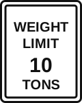
WEIGHT LIMIT 10 TONS on a bridge is a structural statement, taken from a load rating of that specific structure. It is a claim about what the deck will carry.
NO THRU TRUCKS is a municipality keeping freight off a residential street. It is a claim about what the neighborhood will tolerate.
One is physics. The other is a traffic-and-parking matter. To a freight carrier they genuinely are the same, because both end in a citation. To an engine company they could hardly be less alike.
The bridge, briefly
Take the structural sign first, because there is not much to say about it. FHWA’s load-rating guidance for the FAST Act’s emergency vehicles is asked directly whether emergency vehicles are restricted from crossing when they exceed a posted limit, and answers Yes. Around half the states do exempt fire apparatus from the vehicle code’s weight limits, but that removes a citation rather than adding capacity to a bridge. Vermont’s DOT puts it best:
While fire apparatus and emergency response vehicles may choose to cross a bridge, the posting will identify the risk.
So the load-posted bridge earns its detour. Good. That is not where your minutes are going.
Where your minutes are going
Your minutes are going to the other sign, and there are far more of them.
Through-truck ordinances and truck-route designations are dense in exactly the places calls come from: subdivisions, residential grids, the streets around a downtown core. Every one of them between the house and the incident is avoided with precisely the rigor a weak bridge gets. Stack four or five across a run and the detour is no longer marginal.
And none of them are about you. A through-truck ordinance regulates freight traversing a neighborhood on its way somewhere else. An engine responding to a house on that street is not through traffic in any sense the ordinance contemplates, and never was.
The software models one exception, and it isn’t yours
This is not a subtle failure. It is written down. Trimble’s CoPilot documentation describes how it handles exactly these streets:
Legal Restrictions – These are roads that are legally restricted to all vehicles or restricted specifically to trucks. That includes roads specified as ‘No Thru Traffic’ or ‘Delivery Only,’ which will be used in routing only if a delivery or pick-up stop is on that road.
Read the last clause twice. The product does contain the idea of legitimately entering a restricted street: it is a delivery. Freight has an errand there, so the restriction lifts. There is no equivalent for an incident, because nobody building it had one in mind. The same guide is blunt about the default: “CoPilot will never include a road on a route with a restriction that conflicts with the truck routing profile.”
Garmin makes the general point itself, in the warning printed alongside the feature that makes the product worth buying:
Entering your vehicle profile characteristics does not guarantee that your vehicle’s characteristics will be accounted for in all route suggestions… Always defer to all posted road signs and road conditions when making driving decisions.
Read that as a freight carrier and it is boilerplate. Read it as a battalion chief and it is a product telling you in writing that it is a convenience, not a safety system.
What a navigation system owes you
It owes you the difference between the two signs.
Blue Light Maps works from the rig you are actually on, and from there the department sets policy rather than the software guessing it. Restrictions can be respected everywhere, or the department can flag individual structures, so routes avoid the load-posted bridge on the north side while treating the residential ordinances as what they are. Every restriction a route crosses or avoids is marked on the map, so the officer sees the decision instead of discovering it at the abutment.
The deck either holds or it doesn’t, and no software knows that. What it can do is stop pretending a neighborhood ordinance and a weak bridge are the same sign.