The Challenge
Every second counts on the way to an incident. With increased use of fire coverage tools, crews are often rotated to cover areas they don’t know well.
That means they not only need the fastest blue light route – they also need access to vital information like hydrant locations and risk data.
Traditionally, getting up-to-date data into the hands of frontline firefighters has been slow and ardous.
The Solution
Dorset & Wiltshire Fire and Rescue Service has deployed Blue Light Maps to the existing in-vehicle tablets of all frontline fire appliances.
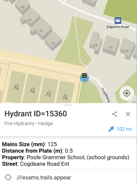
Through a simple data admin panel, the team can upload fire hydrant and risk data in their existing formats. It’s then immediately made available to all frontline crews as an overlay to the base map, alongside comprehensive building data from Ordnance Survey.
The Impact
Daniel Grew, Operational Communications Technology Manager, explained how the app helps:
We have been using the Blue Light Maps app in 40 of our specialist frontline vehicles and it has made a positive difference in reaching incidents more quickly and effectively
The app’s intuitive interface enables crews to quickly select the most suitable routing method. Customised overlays displaying hydrant locations and risk information provide vital insights before arriving on scene.
We often deploy firefighters from wider operational areas who may be unfamiliar with the local road network so having a way of quickly selecting the most suitable route for them can be timesaving.
Daniel Grew, Operational Communications Technology Manager
Dorset & Wiltshire Fire and Rescue Service
What's next?
Dorset & Wiltshire are now exploring opportunities to further expand the use of the Blue Light Maps solution, by also providing access to all responding officers to ensure all responders benefit from smarter routing, critical data overlays, and improved situational awareness.


