Blue Light Maps Integrates Naurt’s Entrance and Parking Data to save crucial seconds for emergency services.
London, UK – Tuesday, 4th of November 2025 – Blue Light Maps has partnered with location-data specialist Naurt to integrate high-accuracy front-door coordinates originally developed for the delivery and logistics sector into emergency-service mapping systems.
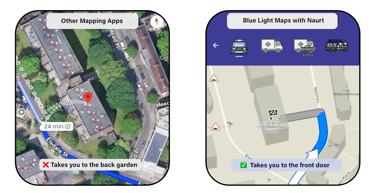
The partnership enables fire, police and ambulance services to pinpoint exact building entrances faster and more reliably than ever before. By using Naurt’s data, which has mapped over 30 million UK door and parking locations, Blue Light Maps can guide responders directly to the right entrance point, saving crucial seconds when every moment counts.
Traditional geocoders typically return a coordinate for the centre of a building or a general area, rather than the precise location of an entrance. This often leaves delivery drivers and emergency services searching for the correct front door, costing time, causing frustration, and sometimes delaying critical responses. Naurt solves this by ensuring that the delivery driver and responders reach the exact point of entry the first time.
“Emergency services face many of the same challenges as couriers: complex addresses, multi-entrance buildings and rural properties that are hard to locate,” said Henry Sternberg, Director at Blue Light Maps. “Partnering with Naurt lets us reuse proven innovation from another industry and apply it where it can make a real difference, getting crews to the correct door faster.”
Daniel Grew, Operational Technology Manager at Dorset & Wiltshire Fire Service said “We have been using the Blue Light Maps app in 40 of our specialist frontline vehicles and it has made a positive difference in reaching incidents more quickly and effectively”.
Jack Maddalena, CEO and Founder of Naurt, added: “We’ve spent years helping delivery companies reach the right front door, and we’re proud to see that same technology now helping emergency services save lives. This partnership shows how accurate, real-world location data can deliver real-world impact.”
Naurt’s data, derived from millions of delivery journeys, provides door-level accuracy and parking spot coordinates for nearly every address in the UK. Blue Light Maps’ integration uses this data to improve routing, navigation and situational awareness in both online and offline modes.
The collaboration demonstrates how commercial sector innovation can strengthen public sector performance, giving emergency responders the precision they need to arrive at the right location the first time.
To learn more about Blue Light Maps’ specialist mapping and routing tools for emergency responders, supporting police, fire and ambulance services with data-driven navigation designed for blue-light conditions. Visit www.bluelightmaps.com
To discover how Naurt’s building entrance and optimal parking data can transform last-mile logistics, visit www.naurt.com
###
Notes to the editor:
Media images can be found here. For further information, please contact the Naurt press office: press@naurt.com
About Blue Light Maps:
Blue Light Maps develops specialist mapping and routing tools for emergency responders, supporting police, fire and ambulance services with data-driven navigation designed for blue-light conditions. www.bluelightmaps.com
About Naurt:
Naurt is a global location data company specialising in high-accuracy datasets of building entrances and parking spots. Naurt’s data is leveraged by logistics providers and technology platforms worldwide to improve service delivery and operational efficiency. www.naurt.com