
Upcoming Blue Light Show1–2 Jul · Olympia, London · See us @ stand Q5 for live demos Event details ↗

Fire service gets smarter maps

How Dorset & Wiltshire Fire and Rescue Service deployed Blue Light Maps.

In numbers

40
Specialist vehicles deployed to
1.45 million
Residents covered
2
Live data overlay types
OS
Base map building data
DG
Daniel Grew
OPERATIONAL TECHNOLOGY MANAGER · DORSET & WILTSHIRE FIRE AND RESCUE SERVICE

"It has made a positive difference in reaching incidents more quickly and effectively."

The Challenge

Every second counts on the way to an incident. With increased use of fire coverage tools, crews are often rotated to cover areas they don’t know well.

That means they not only need the fastest blue light route – they also need access to vital information like hydrant locations and risk data.

Traditionally, getting up-to-date data into the hands of frontline firefighters has been slow and expensive.

The Solution

Dorset & Wiltshire Fire and Rescue Service has deployed Blue Light Maps to the existing in-vehicle tablets of all frontline fire appliances.

Through a simple data admin panel, the team can upload fire hydrant and risk data in their existing formats.

It’s then immediately made available to all frontline crews as an overlay to the base map, alongside comprehensive building data from Ordnance Survey.
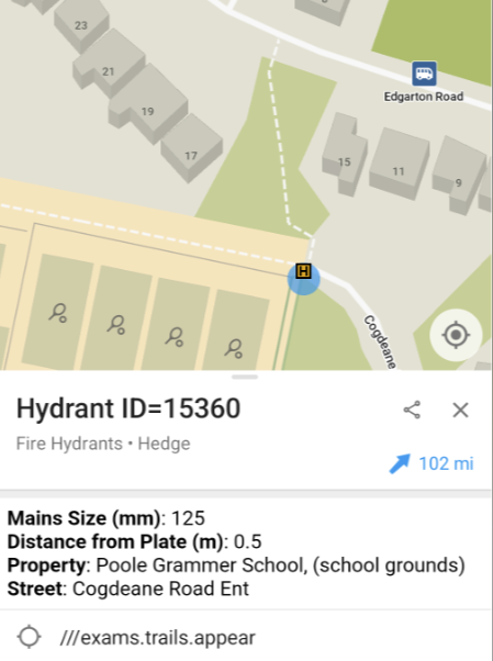
Hydrant and risk-data overlays shown on the base map in Blue Light Maps

The Impact

Daniel Grew, Operational Communications Technology Manager, explained how the app helps:

What’s next?

Dorset & Wiltshire are now exploring opportunities to further expand the use of the Blue Light Maps solution, by also providing access to all responding officers — ensuring every responder benefits from smarter routing, critical data overlays, and improved situational awareness.

Ready when you are

Equip responders with smarter maps.

30-minute walkthrough. Trial in your area.
No commitment until your team is sold.

Trusted by responders · Operationally proven

Summary

Dorset & Wiltshire Fire and Rescue Service has implemented Blue Light Maps on their in-vehicle tablets to improve incident response times and effectiveness. The system allows for the quick upload and dissemination of vital data, such as hydrant locations and risk information, to frontline crews. This aims to overcome traditional challenges of slow and expensive data distribution, enhancing situational awareness for responders.

Key Facts

Frequently Asked Questions

What results did Dorset & Wiltshire Fire and Rescue Service achieve with Blue Light Maps?

The system has made a positive difference in reaching incidents more quickly and effectively. They are also exploring opportunities to further expand the use of the Blue Light Maps solution by providing access to all responding officers.

What was the challenge faced by Dorset & Wiltshire Fire and Rescue Service?

With increased use of fire coverage tools, crews are often rotated to cover areas they don’t know well. They need not only the fastest blue light route but also access to vital information like hydrant locations and risk data. Traditionally, getting up-to-date data to frontline firefighters has been slow and expensive.

How was Blue Light Maps deployed by Dorset & Wiltshire Fire and Rescue Service?

Dorset & Wiltshire Fire and Rescue Service deployed Blue Light Maps to the existing in-vehicle tablets of all frontline fire appliances. Through a simple data admin panel, the team can upload fire hydrant and risk data in their existing formats, which is then immediately made available to all frontline crews as an overlay to the base map, alongside comprehensive building data from Ordnance Survey.

Related Entities

People
Daniel Grew
Companies
Dorset & Wiltshire Fire and Rescue Service, Blue Light Maps, Ordnance Survey
Products
Blue Light Maps
Locations
Dorset, Wiltshire, London, Olympia
Technologies
fire coverage tools, in-vehicle tablets, data admin panel, base map, OS, DG