
Upcoming Blue Light Show1–2 Jul · Olympia, London · See us @ stand Q5 for live demos Event details ↗

Blue Light Alert®

We can pre-warn nearby drivers that a blue-light vehicle is approaching, so traffic reacts sooner and clears the path for emergency vehicles.

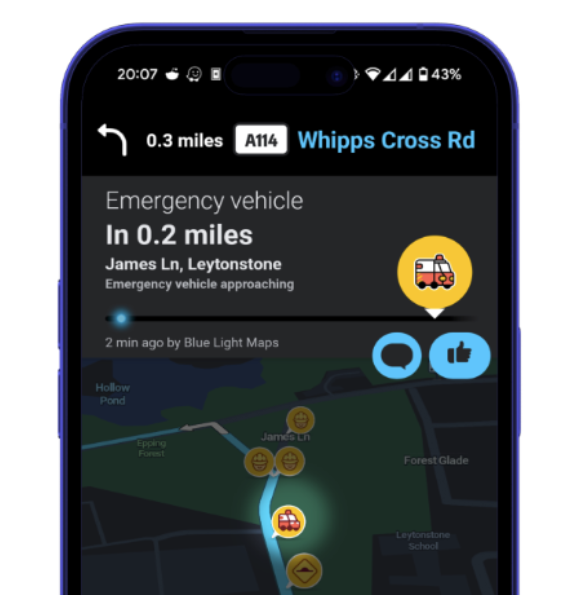
Blue Light Maps approaching-vehicle alert shown to a nearby driver in Waze

Lights and sirens are often noticed at the last-second. By the time a driver sees blue lights in the mirror or hears the siren over their music, there’s little time to react calmly, so they often brake late, swerve, or freeze.

Blue Light Alert® gets ahead of that. During navigation to an emergency call, we broadcast an approaching emergency vehicle alert into Waze along the route - reaching drivers before they can see or hear the emergency vehicle coming, giving them more time to notice and to move over.

Every month
16k+
Alerts generated
42k+
Drivers alerted
9,090+
Alert upvotes

Why a head start matters

The danger in blue light driving isn’t only that other drivers don’t slow down, it’s variability. Some brake hard, some don’t slow at all, and that unpredictability is what causes collisions and impacts response times.

A warning that arrives early lets drivers adjust smoothly, together, well before the blues appear in their mirror, reacting 4× further out than they would to lights alone.

The evidence

Independent research backs this up. A 2026 University of Illinois field study filmed thousands of vehicles approaching live roadside scenes from the air, comparing how they behaved with and without an in-vehicle digital alert. A University of Minnesota study put 85 drivers through emergency-vehicle encounters at junctions in a driving simulator.

Both found the same thing: drivers warned before they can see a vehicle react sooner, more smoothly, and collide far less often.

4×
further reaction distance vs. emergency lights alone
−43%
speed variability when digital alerts are active
−70%
lower odds of a collision with an emergency vehicle

Reaction-distance & speed-variability figures: University of Illinois & Illinois Center for Transportation, FHWA-ICT-26-003 (2026). Collision-risk figure: Drucker, C.J. (2013), University of Minnesota (odds ratio 0.30, simulator phase, n=85).

How it works

  1. An incident is dispatched to crews using your existing systems.
  2. The responding crew uses Blue Light Maps in ‘emergency’ mode to navigate to the incident.
  3. Blue Light Alert® automatically broadcasts approaching emergency vehicle alerts into Waze along the route, and stationary emergency vehicle alerts for incidents on fast roads.

More accurate, because we know the route

Hardware beacons and location-only services can only flag that an emergency vehicle is somewhere nearby, right now. Because Blue Light Alert® runs on the responding crew’s live navigation, we know the exact route they’re taking. That means we warn the right drivers earlier and with fewer false alarms for everyone else.

The cost of doing nothing

£4.5m
a year in blue-light collision costs at Thames Valley Police alone
200+
blue-light collisions every year
£22.5k
average cost per collision (£3.5k payout + £19k fleet)

Source: FOI request to Thames Valley Police.

Download the evidence brief (PDF)

More capabilities

Blue Light Routing

Developed alongside emergency crews, our routing algorithms understand what helps first responders get to scene quicker.

Learn more →

Trusted data

The geospatial data your control room trusts, on the responder's map.

Learn more →

Custom data layers

Overlay your own datasets on every responder's map. Converted from the formats you already hold, visible by role, available offline.

Learn more →

Ready when you are

Equip responders with smarter maps.

30-minute walkthrough. Trial in your area.
No commitment until your team is sold.

Trusted by responders · Operationally proven

Summary

Blue Light Alert® is a system designed to pre-warn drivers of approaching emergency vehicles via Waze, allowing traffic to react sooner and clear the path. It broadcasts alerts along the navigation route, providing drivers with more time to adjust smoothly and reduce collision risks. The system is more accurate than traditional beacons because it uses the exact route of the responding vehicle.

Key Facts

Frequently Asked Questions

How does Blue Light Alert® work?

An incident is dispatched to crews using your existing systems. The responding crew uses Blue Light Maps in ‘emergency’ mode to navigate to the incident. Blue Light Alert® automatically broadcasts approaching emergency vehicle alerts into Waze along the route, and stationary emergency vehicle alerts for incidents on fast roads.

Why is Blue Light Alert® more accurate than hardware beacons?

Hardware beacons and location-only services can only flag that an emergency vehicle is somewhere nearby. Because Blue Light Alert® runs on the responding crew’s live navigation, it knows the exact route they’re taking, warning the right drivers earlier and with fewer false alarms.

What is the evidence supporting the effectiveness of digital alerts?

Independent research, including a 2026 University of Illinois field study and a University of Minnesota driving simulator study, found that drivers warned before they can see a vehicle react sooner, more smoothly, and collide far less often.

Related Entities

Companies
Blue Light Maps, Waze, Thames Valley Police, University of Illinois, University of Minnesota, FHWA-ICT
Products
Blue Light Alert®, Blue Light Maps
Locations
Olympia, London, Illinois, Minnesota
Technologies
Waze