Upcoming Blue Light Show1–2 Jul · Olympia, London · See us @ stand Q5 for live demos Event details ↗

Custom data layers

Overlay your own datasets on every responder's map. Converted from the formats you already hold, visible by role, available offline.

A fire hydrant from the service's own data shown on the Blue Light Maps base map, with its full record - mains size, distance from plate, property and access notes

Built around your data, not ours

Every service holds data commercial mapping providers never will. Hydrant locations and mains sizes for fire. ANPR cameras and patrol priorities for police. Defibrillators, property risk records, asset stores.

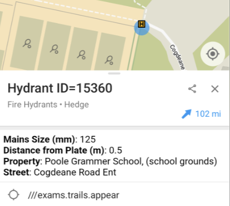
Custom data layers empower the frontline with the data directly on the responder’s map: on every device, in the field, available offline.

Your formats, converted for you

You shouldn’t have to reshape your data to get it on the map. Push it from your GIS or ArcGIS feeds, hand us a CSV export, or upload it directly in a simple admin panel. We convert from the formats you already hold, so a hydrant export becomes a tappable asset that still carries every field it came with.

It’s the same workflow Dorset & Wiltshire use: their team uploads hydrant and risk data in its existing formats, and it’s immediately available to all frontline crews as an overlay on the base map.

Visible when it matters

Layers can sit on by default for the crews who always need them, or stay tucked away for responders to toggle on when a job calls for it.

What you can put on the map

A layer is just points, lines or areas with your data attached, so the possibilities are as broad as your operations:

  • Slipways and launch points for deploying rescue boats, with access and tide notes attached.
  • Public-access defibrillators, so the nearest unit is one tap away.
  • Priority patrol areas based on predictive policing models, refreshed as the intelligence picture changes.
  • Water sources, rendezvous points and asset stores for major incidents.

If your service depends on something that’s somewhere, it should live on the map - making it accessible to those that need to know.

More capabilities

Blue Light Routing

Developed alongside emergency crews, our routing algorithms understand what helps first responders get to scene quicker.

Learn more →

Blue Light Alert®

We can pre-warn nearby drivers that a blue-light vehicle is approaching, so traffic reacts sooner and clears the path for emergency vehicles.

Learn more →

Trusted data

The geospatial data your control room trusts, on the responder's map.

Learn more →

Ready when you are

Equip crews with smarter maps.

30-minute walkthrough. Trial in your area.
No commitment until your team is sold.

UK-based · Trusted by responders · Operationally proven

Summary

Blue Light Maps offers custom data layers that enable emergency responders to overlay their own datasets onto maps. These layers can be converted from various existing formats, made visible by role, and accessed offline. The service supports points, lines, and areas with attached data, empowering frontline crews with critical information relevant to their operations.

Key Facts

Frequently Asked Questions

What is the primary function of custom data layers on Blue Light Maps?

Custom data layers allow you to overlay your own datasets on every responder's map, making them visible by role and available offline.

What data formats can be used for custom layers?

You can push data from GIS or ArcGIS feeds, upload a CSV export, or upload it directly through a simple admin panel; the service converts from the formats you already hold.

How can custom data layers be controlled for visibility?

Layers can be set to sit on by default for crews who always need them, or responders can toggle them on when a job calls for it.

What types of data can be mapped using custom layers?

The possibilities are broad, including slipways and launch points, public-access defibrillators, priority patrol areas, water sources, rendezvous points, and asset stores.

Related Entities

Companies
Blue Light Maps, Dorset & Wiltshire
Products
Blue Light Routing, Blue Light Alert®
Locations
Olympia, London, Dorset, Wiltshire
Technologies
GIS, ArcGIS