Upcoming Emergency Tech Show16–17 Sep · NEC Birmingham · Visit us in Ordnance Survey's Mapping Zone Event details ↗

New shortcuts for Oxford’s Emergency Services

Oxford is replacing Low Traffic Neighbourhood bollards with ANPR cameras, opening time-saving shortcuts for exempt vehicles — including emergency services.

navigationnews

At the end of April 2024, Oxford County Council will be amending Low Traffic Neighbourhood schemes to remove bollards and replace them with ANPR cameras for enforcement of these no-through roads.

Bollards will be removed on the following roads:

  • Divinity Road
  • James Street
  • Magdalen Road
  • Crescent Road
  • Littlehay Road
  • Littlemore Road

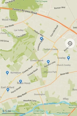
Map of Oxford LTN roads losing bollards

Exemptions will be in place for the below vehicles to make use of these time-saving shortcuts:

  • Taxis
  • Private hire vehicles
  • Emergency service vehicles
  • Local authority waste vehicles
  • Royal Mail vehicles

This move brings these traffic filters in-line with many other schemes in Oxford, the UK and further afield that seek to reduce the impact of motorised vehicles in local neighbourhoods, while balancing the needs of essential services.

The main benefit of Low Traffic Neighbourhoods is to reduce through-traffic using local roads as rat runs between larger arterial roads. However, with many drivers of exempt services relying on generic GPS navigation solutions, the life saving time benefits of using these shorter routes won’t be realised.

Blue Light Maps is the only navigation solution that allows Emergency Service drivers to find shorter routes that make use of their exemptions from schemes like those in Oxford, with Blue Light Routing frequently finding routes up to 60% shorter than those available for the general public, offering clear benefits for response times and public safety.

Our routing algorithm will start offering these new shortcuts to first responders in our May update.

Individuals can download the app from the App Store or Play Store, or contact us to discuss how we can help your organisation.

Ready when you are

Equip responders with smarter maps.

30-minute walkthrough. Trial in your area.
No commitment until your team is sold.

Trusted by responders · Operationally proven

Summary

Oxford County Council will replace Low Traffic Neighbourhood bollards with ANPR cameras at the end of April 2024, affecting six roads. Exempt vehicles including taxis, emergency services, and Royal Mail will be able to use these routes as shortcuts. Blue Light Maps, a navigation solution for emergency services, will incorporate these new shortcuts into its routing algorithm starting in May, potentially reducing response times by up to 60%.

Key Facts

Frequently Asked Questions

What is happening to the Low Traffic Neighbourhood bollards in Oxford?

Oxford County Council will be removing bollards and replacing them with ANPR cameras for enforcement of no-through roads at the end of April 2024.

Which roads are affected by the bollard removal?

The bollards will be removed on Divinity Road, James Street, Magdalen Road, Crescent Road, Littlehay Road, and Littlemore Road.

Which vehicles are exempt from the new ANPR cameras?

Exemptions are in place for taxis, private hire vehicles, emergency service vehicles, local authority waste vehicles, and Royal Mail vehicles.

How does Blue Light Maps help emergency services use these shortcuts?

Blue Light Maps is the only navigation solution that allows emergency service drivers to find shorter routes using their exemptions, with Blue Light Routing frequently finding routes up to 60% shorter.

When will Blue Light Maps start offering these new shortcuts?

The routing algorithm will start offering these new shortcuts to first responders in the May update.

Related Entities

Companies
Blue Light Maps, Oxford County Council, Royal Mail
Products
Blue Light Routing, Blue Light Maps app
Locations
Oxford, Divinity Road, James Street, Magdalen Road, Crescent Road, Littlehay Road, Littlemore Road
Technologies
ANPR cameras